 Slovenska verzia
 Русская версия
| Slovenska verzia |
Русская версия
|
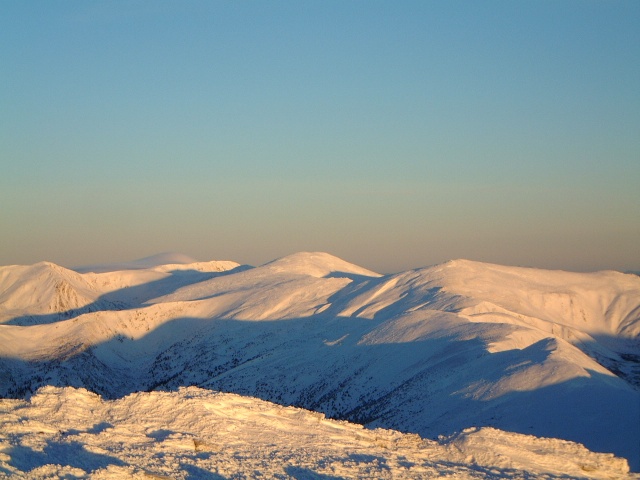 |
The Carpathians mountains look like a gigantic arc on the map of Europe. The middle part of the ark is situated in the Western Ukraine. The highest point is the summit Hoverla (2061m). Mainly the mountains are covered by virgin fir-tree, beach and beam-hornforests with rich flora & fauna. The local people, the ethnical group of Ukrainians which are called Hutsuls. Due to being isolated by the mountains, those people boast unique architecture,picturesque costumes etc. Having a rather developed network offtrails, this part of the Carpathians is beneficially distinguished from the parts in the neighbouring countries by not being overcrowded which hill-walkers. That fact allows to face wild nature instead of crowds of hikers. |
CURRENT ROUTES .
For example : Gorgany region : trekking in the neighbourhood of the summits Sivula (1836m), Doboshanka (1754m), Visoka(1805m), Grofa (1748) ,Bushtul (1660m),Bratkovska(1780m), pass Legionov and many more. With the starting /ending points as Yaremcha,Bistritsa,Osmoloda , Tatatrov, Miculichin, Zelena,Huta etc.
Chernogora range :Hoverla (2061m),Petros(2020m),Berbeneskul(2037m),Pop Ivan(2022m) ,etc.
The starting /ending points Vorohta, Lazeshina,Rahov,Dzembronya,Yasinya etc.
Svidovets range : Bliznitsa(1880m),Dolgaska(1707m),Ungaryaska(1700m), etc.
The starting /ending points Rahov,Yasinya,Bistritsa,Lopuhov,etc.
Poloninskij range: Borzhava with the summit Stoj(1660m), etc.
The starting /ending points Volovets, Svalyava etc.
Routes from number 1 to 7 grades as simple or moderate with all or most of overnight stays in private houses or hotels(under the roof) . Routes with number 7 and bigger grades as difficult and most overnight stays are in tents.
| Number | Route(click to get the full discription) | Start | End | Short discription | Days |
| 1 | The highest mountains of Ukraine. | Yaremcha(60km south from Iv-Fr) | Huta(60km south-west from Iv-Fr) | This route leads to the highest summit of Ukraine along with hiking ih the other highest ranges, all overnight staying in hotels,huts and private places sometimes with basic facilities. Average time for everyday walking is 5h. | 10 |
| 1A | The highest mountains of Ukraine(short variant). | Yaremcha(60km south from Iv-Fr) | Zaroslak ( 115km south from Iv-Fr) | This route leads to the highest summit of Ukraine along with hiking ih the other highest ranges, all overnight staying in hotels,huts and private places sometimes with basic facilities. Average time for everyday walking is 5h. | 6 |
| 2 | Around Yaremcha. | Yaremcha(60km south from Iv-Fr) | Manyava(50km south-west from Iv-Fr)or Zaroslak( 115km south from Iv-Fr) | Hiking in vicinity of Yaremcha , with optional Hoverla assent and Manyava waterfall and monastery visiting. All overnight staying in hotels and private places. Average time for everyday walking is 5h. | 6 |
| 2A | Around Yaremcha(short). | Yaremcha(60km south from Iv-Fr) | Manyava(50km south-west from Iv-Fr) | Hiking in vicinity of Yaremcha , Pasechna waterfall and Pniv ruins visiting. All overnight staying in hotels and private places. Average time for everyday walking is 3h. | 6 |
| 3 | The river Prut valley. | Zaroslak( 115km south from Iv-Fr) | Manyava(50km south-west from Iv-Fr) | Ascending on Hoverla, seeing hutzul villages, hiking in Gorgany massif of ll overnight staying in hotels and private places. Average time for everyday walking is 5h. | 5 |
| 4 | Hoverla-Bliznica-Yaremcha | Zaroslak( 115km south from Iv-Fr) | Yaremcha(60km south from Iv-Fr) | Ascending on Hoverla, hiking the Western part of the Chernogora range, Svidovets, Most overnight staying in hotels and private places , 1 or 2 nights camping in tents. Average time for everyday walking is 5h. | 7 |
| 5 | Mobile motorised trip | Zaroslak( 115km south from Iv-Fr) | Manyava(50km south-west from Iv-Fr)or Bystritsa(65km south-west from Iv-Fr) | Ascending on Hoverla, and some summits in Gorgany massif , using a car almost everyday changing palces. Most overnight staying in hotels and private places, camping as alternative. Average time for everyday walking is 5h. | 7 |
| 6 | Complete traverse of the main Gorgan range , including all summits | Tatarov ( 80km south from Iv-Fr) | Myslivka(80km west from Iv-Fr) | Tough hiking through the main range of Gorgany massif , most overnight staying in tent, roaming through virgin landscape and vegetation , sometimes without convenient trails, taking all summits of the Main Gorgan range. Average time for everyday walking is 8-10h. | 6 | 6a | Traverse of the main Gorgan range | Tatarov ( 80km south from Iv-Fr) | Myslivka(80km west from Iv-Fr) | Hiking through the main range of Gorgany massif , most overnight staying in tent. Average time for everyday walking is 5-8h. | 7 | 7 | Yaremcha-Huta-Osmoloda | Yaremcha( 60km south from Iv-Fr) | Osmoloda(75km south-west from Iv-Fr) | Hiking from Yaremcha till Huta through Gorgany massif including the highest Gorgany pick Sivulya , most overnight staying in tent. Average time for everyday walking is 6-10h. | 6 | 8 | Manyava_Yaremcha | Manyava(50km south-west from Iv-Fr) | Yaremcha( 60km south from Iv-Fr) | Hiking from Manyava near waterfall till Yaremcha through Gorgany massif,sometimes without convenient trails , most overnight staying in tent. Average time for everyday walking is 5-10h. | 6 | 9 | Chernogora and Svidovets | Dzembronya(135km south from Iv-Fr) | Bystritsa(65km south-west from Iv-Fr) | Hiking from remote hutsul village Dzembronya till Bistritsa through Chernogora and Svidovets massif, most overnight staying in tent. Average time for everyday walking is 5-10h. | 7 | 10 | From Chernogora to Gorgany | Bistrec(130km south from Iv-Fr) | Huta(60km south-west from Iv-Fr) | Hiking from remote hutsul village Bistrec till Huta through Hoverla , Bliznitsa and Legionov pass, most overnight staying in tent. Average time for everyday walking is 5-10h. | 7 | 11 | The heart of Gorgany | Huta(60km south-west from Iv-Fr) | Osmoloda(75km south-west from Iv-Fr) | Hiking in the highest and wildest part of Gorgany, most overnight staying in tent. Average time for everyday walking is 5-10h. | 9 | 12 | The heart of Gorgany2 | Huta(60km south-west from Iv-Fr) | Bistrica(65km south-west from Iv-Fr) | Hiking in the highest and wildest part of Gorgany, most overnight staying in tent. Average time for everyday walking is 5-10h. | 8 | 13 | Minor Gorgan range | Mikulichin(70km south from Iv-Fr) | Yasen(65km south-west from Iv-Fr) | Hiking along the minor Gorgan range, most overnight staying in tent. Average time for everyday walking is 5-8h. | 4 | 14 | Trans Prut ranges | Yaremcha( 60km south from Iv-Fr) | Vorokhta(80km south from Iv-Fr) | Hiking in the mountains east of the Prut river, most overnight staying in tent. Average time for everyday walking is 5-8h. | 5 |
BACK
Do not hesitate to contact me via e-mail:
carpathians2000@yahoo.com or
gorgany@rambler.ru
Phone:
+(038)-067-342-84-07